
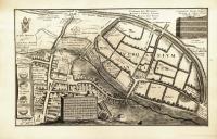
Plate 1.8: Plan of Ancient Verulamium
Object: An extensively labeled map of the Roman remains of Verulamium with inset images of a section of Roman wall (upper right) and the arms of St. Alban’s Abbey along with two ancient British coins (left margin, top to bottom). The Roman ruins today are encompassed by the modern city of St. Albans in Hertfordshire. A tablet with two broken columns and a Latin inscription addressing the purpose of the map are added on the lower left, creating the somewhat incongruous impression of a hill from which the viewer looks down on the map. The inscription refers to the map as a “cenotaph of the [Roman] city,” but the map also identifies a large number of medieval features in addition to Roman roads, mosaics, and remains of the ancient wall and other defenses. The medieval ecclesiastical history is especially well documented, with locations being given for the abbey church (St. Alban’s Cathedral), the Eleanor Cross, St. Stephen’s Church, the Chapel of St. Mary Magdalene, St. Julian’s Almshouse, Sopwell Priory, St. Michael’s Church, St. Peter’s Church, St. Mary’s Priory, and the Chapel of St. Germanus, structures dating from the eighth through the thirteen centuries, only some of which survive. Many structures, both medieval and Roman, were actively being dismantled at the time of Stukeley’s visit, as he noted in his Itinerarium Curiosum (1776, 1.116).
Transcription:
Click here to access an interactive map providing full transcription and translation details for Plate 1.8.
Upper Left Quadrant:
Sti Iuliani Ptochotrophium fundatum a Galfrido Abbate circa 1120
Ecclesia Stephani ab Ulsino Abbate aedificata circa 950
Via Romana Watlin Street vocata
Insignia Monasterii
Fossa nunc Tonman ditch
Porta Urbis Antiquae
Fossa profunda
Sopwell Domus Monialium fundata 1140 a Galfrido Abbate
Fons Sacer
Holy Well
Canalis Subteraneus
Ecclesia Caenobij ab Offa Rege fundata fuit cicra 793 e ruinis Verolanij
Agger Fishpoolhead ex ruinis Urbis confectus
Capella Stae. Mariae Magdalenae aedificata ab Ulsino Abbate hodie omnino Sublata.
Murus hic Aratro complanatus.
Pars muri adhuc residua
Vestigia
Agger Altissimus cuius summitatem adhuc aequat murus circa 9 ped. latus.
Via Londinum Versus
Rudera Caenobij
Caenobij Molendinum
Burgus Sti Albani ubi olim Sylva Holmshurst Anglorum Proto-martyris (sub Dioclesiano) morte clara
Upper Right Quadrant:
Verolanium Urbs Britannico-Romana a Voadicia Icenorum Regina Sub Nerone excisa fuit.
Via Hemstediam ducens
Constructionis Mur[or]um Antiquoru[m] Specimen ex Silicis et Laterum Ordinibus alternis.
Southgate
Fossa duplex
Muri Antiqui Reliquiae
Cavitas
Trames pedestris
Heic porta olim fuisse videtur
Murus hic Sepibus coronatur Sat tamen conspicuus
Scala Pedum
Trames ducens ad Gorhambury Villam olim Vicecomitis Verolanij
Vestigia
Umbra Strati
Vestigia
Pavimentum tesselatum
Sti Germani Capella ubi Synodus olim celebrata ab Ulso Priore fundata circa 945 nunc penitus versa.
VEROLANIVM ANTIQVUM
Left Banner: Nummi Antiqui Brittannici / Verolamium Civitas / Boadicia Regina
Bottom Left Quadrant:
Claustrum
Porta Caenobiij
Stagnum olim desiccatum ab Alfirico Abbate circa 960 nunc prata
Ecclesia Caenobii
Rome Land
Campanile
Crux Memoriae Eleonorae Reginae Sacra, ab E.I exstructa
Vicus Vulgo Fishpool Street
Ecclesia Divi Petri aedificata Ulsino Abbate 950
Horti
Ne cineres etiam Verolanij penitus aboleantur: Vestigia Romanorum in Municipio olim celeberrimo quantum ex ruderibus fieri potest adumbrata, velut Tantae Vrbis Cenotaphium Societati Antiquariae Londinensi cujus impensis aeri incisum, vovet. W.s Stukeley. Anno 1721
Bottom Right Quadrant:
Ecclesia Divi Michaelis ubi dormitat Magnus Verolanius; aedificata ab Ulsino Abb. 950.
Domus parochi
Pastura plana super Murum
nunc Arva & Pascua
Pars Muri adhuc restans Gorhamblock nuncupata.
Vallis appellata “The Hollowes”
Tonman Ditch
Molendinum de Kingsbury olim Manerium Regium & Castellum
Murus heic ad fundamentum erutus
Prata
Colne Fluvius
Via Regia ad Redburn Non longe hinc Prioratus S[anc]tae Mariae de pratis.
Oster Hill
Scala Pedum
Translation:
Click here to access an interactive map providing full transcription and translation details for Plate 1.8.
Upper Left Quadrant:
St. Julian’s Almshouse founded around 1120 by Abbot Geoffrey
St. Stephen’s Church, built by Abbot Wulsin around 950.
Roman road, called Watling Street
seal of the Monastery
a trench, now Tonman ditch
gate of the ancient city
a deep ditch
Sopwell Priory, founded in 1140 by Abbot Geoffrey [de Gorham]
Holy Well
underground canal
The Monastery Church was founded by King Offa around 793 from the ruins of Verolamium.
Fishpoolhead Causeway made from the ruins of the city
Chapel of St. Mary Magdalene, built by Abbot Wulsin, today entirely destroyed.
This wall leveled by a plough.
A part of the wall still remaining.
remnants
A very high rampart, whose highest point is level with the wall, about 9 feet wide.
the road toward London
ruins of the abbey
monastery’s mill-house
City of St Albans where [there was] once a Forest, Holmhurst [Holywell Hill], famous for the death of the first Martyr of the English (under Diocletian).
Upper Right Quadrant:
A British-Roman City, Verulamium, was destroyed by Boudica, Queen of the Iceni during Nero’s reign.
A road leading to Hempstead.
Model of the construction of the ancient walls, made out of alternating layers of rubble [flint] and bricks.
Southgate
a double ditch
relics of the ancient wall
a hollow
footpath
A gate appears to have been here once.
This wall is surrounded by hedges and yet sufficiently visible.
scale of feet
A path leading to Old Gorhambury House, once belonging to the Earl of Verulam.
remnants
traces of a paved road
remnants
Mosaic pavement
Chapel of St. Germanus [of Auxerre] where a Synod was once held, founded by Ulf, Prior [of St. Albans] around 945. Now entirely destroyed.
Ancient Verulamium
Left Banner: Ancient British Coins / City of Verolamium / Queen Boudica
Bottom Left Quadrant:
cloister
abbey gate
Swamp, once drained by Abbot Aelfric around 960, now a meadow.
St Alban’s Abbey Cathedral
Rome Land
bell tower
Cross Sacred to the Memory of Queen Eleanor, built by Edward I.
a street, commonly known as Fishpool Street
Church of St. Peter, established by Abbot Wulsin
gardens
Lest even the traces [lit. “ashes”] of Verolamium be entirely forgotten, W. Stukeley dedicates [this map of] the ruins of the Romans in this once very famous town, drawn as far as can be done from its remains, as a cenotaph for a city so great, to the Society of Antiquaries of London, at whose expense it was engraved in copper. In the year 1721.
Bottom Right Quadrant:
St. Michael’s Church, where Great Verulamius [Sir Francis Bacon] rests; built by Abbot Wulsin, 950.
Parish house
a flat pasturage beyond the wall
now fields and pastures
Part of the wall still standing, called Gorhamblock.
a valley called “The Hollows”
Tonman Ditch
the Kingsbury Watermill, formerly King’s manor and fortress
The wall here destroyed to the foundation.
meadows
River Colne (or Ver) [actually the River Ver runs through St Albans and joins the Colne 4 km downstream]
Royal Road to Redbourn. Not far from here the Priory of St. Mary of the Meadows [St. Mary de Pratis].
Oster Hill
scale of feet
Commentary by Noah Heringman and Katherine Hobbs: This plate shows a map of the ruined city of Verulamium in Hertfordshire, originally drafted and annotated by William Stukeley on a visit to the site in 1720 or 1721 and augmented during another visit in 1722 (Robson and Bower 2016, 136-37). The site of Verulamium, a municipium under Roman rule that had earlier been occupied by Britons, was subject to a series of wars and invasions and was eventually absorbed into the town of St. Albans after the construction of a Benedictine monastery nearby in the 790s CE. The abbey was built to honor the saint, who was England’s first martyr (Bohun 1710, 8; Heylyn 1709, 195). Verlamion was already well-known in the eighteenth century as a find spot for pre-Roman coins (two are included on this map) and was celebrated as a site of resistance to Roman colonization. As Verulamium, it is the only definite municipium among many Roman sites in Britain (Niblett and Thompson 2005, 41). The early medieval name of the modern city, St. Albans, captures its importance for the history of Christianity in Britain. St. Alban’s execution during Roman times makes him “the first Martyr of the English,” according to the text on the map, and the creation of St. Alban’s Abbey marked an important step in the establishment of Christianity in the Kingdom of Mercia. The project of making this map thus afforded an opportunity for Stukeley to display both classical erudition and zeal for British antiquities in the same compass.
Stukeley visited the site while compiling material for his Itinerarium Curiosum, first published in 1724, about two years after Vertue’s engraving of this map was published by the Society of Antiquaries of London (SAL). He spent several years tracing major Roman roads in many parts of England, and the work is organized around routes recorded in the third-century (CE) Antonine Itinerary. The material on Verulamium/St. Albans, including a greatly simplified version of this map, appears in Stukeley’s fifth itinerary (Iter. V). Since Vetusta Monumenta included no explanatory text prior to 1744, Stukeley’s narrative in the Itinerarium provides the best guide to his reasons for making such a detailed map. The narrative also expands some of the bits of information included as annotations on the map.
In his narrative, Stukeley notes that he rejoined Watling Street at St. Albans; he followed this ancient route from there to London and into Kent. “I need say little here” about “the famous municipium of the Romans, destroyed by Boadicia,” Stukeley observes, deferring to earlier accounts by William Camden and other antiquaries (1776, 1.116). Stukeley goes on to address three significant topics, however: medieval ecclesiastical history, the subject of two more accompanying plates; the prevalence of Roman artifacts in local collections; and the ongoing destruction of both Roman and medieval remains. The last of these provides the most obvious occasion for the map: “three years ago [a] good part of the wall was standing; but ever since, out of wretched ignorance, even of their own interest, they have been pulling it up all around, to the very foundations, to mend the high-way” (116-17). He also comments on the destruction of medieval monuments, including St. Alban’s Abbey (excluding the church), leveled now whereas “three years ago one might make a tolerable guess at the ichnography of the place” (117). The careful recording of the “form of the city” along with the structure of the Roman wall (inset, upper right) appear in this context as a conscious act of preservation; the high altar of the abbey church warranted two more plates as “a curious piece of Gothic work,” though it was not in immediate danger. While he was making his “ichnography” or plan of the city, Stukeley also ran across “pecks of remainders of Mosaic pavements” and noted Roman bronze ornaments and ceramics in local collections.
Verlamion was a wealthy settlement, and was the site of a mint even before the Romans captured and renamed it Verulamium in the first century CE (“Some Account” 1783, 132). Eighteenth-century accounts such as John Collinson’s Beauties of British Antiquity noted the “several pieces of ancient money” found at Verulamium; these seem to match the coins illustrated on the map. The coins were observed to have the inscription “TASCIA” engraved on one side and “VER” on the other, signifying, according to this author, “the tribute of Verulam” since “Tasc, in the British tongue, signifies tribute” (Collinson 1779, 79). In fact, this inscription may refer to the Catuvellauni leader Tasciovanus. A silver coin attributed to this leader, matching the upper one on the plate and found at St. Albans, is preserved at the British Museum. In the sixteenth century, Camden also reproduced a version of the upper coin—Vertue may even have re-engraved this version—but Camden’s view that the “Britans” could not “have coined money before the Romans came among them” was (pace Collinson) no longer uniformly accepted in the eighteenth century (Camden 1789, 337). The name of the River Ver is certainly pre-Roman; confusingly, it is labeled “River Colne” on the map, but in fact the Ver merges into the Colne about 4 km downstream from St. Albans.
The town’s wealth made it appealing to invaders, one of whom was Boudicca, queen of the Iceni, who led a revolt in 60-61 CE. An eighteenth-century history of the abbey, drawing on Tacitus for its account of this revolt against Roman occupation, declares that Verulamium was “rich and opulent[,]… a greater temptation to a plundering foe than mere castles and military posts” (Newcome 1795, 3). Boudicca’s assault receives much attention in eighteenth-century accounts; the appearance of her name reinforces the importance of this episode for the study of British antiquities. John Gifford’s History of England details Boudicca’s ill-treatment by the Romans in quasi-patriotic terms to justify her violent destruction of the Roman city. This queen of “dignified deportment” and “magnanimous spirit” roused the “flame of indignant virtue” in the Iceni and other groups of Britons (Gifford 1790, 1.19). Although not all accounts are so sympathetic to Boudicca’s cause, the destruction of Verulamium as a symbol of Roman rule is presented here as important in regaining lost British dignity. The Saxon period is not discussed by Stukeley, but the map shows the site of Kingsbury Water Mill, near the Saxon settlement established inside the Roman walls and supplanted by the medieval town of St Albans (Nurse 2020, 67).
The ancient site, labeled in large capitals, occupies a large proportion of the map, and it attracted the keen interest of many eighteenth-century observers. The wall is shown in outline winding around the ancient municipium, and Stukeley concludes that it was built after Boudicca’s sack of the town (1776, 1.116). A writer whose travel account is included in the Annual Register for 1782 notes that these Roman walls were added onto pre-existing defenses of ditches and ramparts, underscoring how British and Romano-British history are intertwined on the site. This writer also observes that the area (once) enclosed within the walls is peculiar for being oval-shaped and “depart[ing] from the Rectangular form of the Romans,” speculating that the slope of the land and the river might have contributed to this shape and to the town’s “security” (“Some Account” 1783, 131). The construction of the wall is illustrated in detail in the upper-right hand corner of the map, corresponding to the Annual Register's description of the twelve-foot-thick walls, arranged so that “By intervals of abo[ut] three feet distance, are three, and in some places four, rows of bro[ad] and thin bricks…which seem design[ed] as foundations to sustain the layers of flints and lime” (132). This 1782 account draws not only from the writer’s personal observation but from the present engraving of Stukeley’s map (not the simplified version that appears in the Itinerarium); the writer cites Stukeley’s measurement of Verulamium’s dimensions and in a note refers to his “admirable plan” of the city (132). A recent assessment, nearly as favorable, notes that Stukeley did not rely on earlier source material for this map, as he did for others, and that mapmakers continued to follow it in the nineteenth century; in spite of his lack of archaeological tools and methods, “Stukeley appears to have correctly outlined the approximate overall shape of the site, located most of the gates and begun to identify the grid-iron pattern of roads” (Robson and Brower 2016, 143).
In the eighteenth century, the area formerly within the Roman walls was “inclosed into fields” (“Some Account” 1783, 133), as portrayed on the plate. The same account notes that as the fields were being tilled, the ancient streets were revealed along with various artifacts under the hedges. The most notable was Watling-Street, the major road running all the way “from Dover into the north,” which was the source of the Saxon name for Verulamium, Watlingcester (Geography 1744, 80). Its position on this road was also a key source of Stukeley’s interest. By juxtaposing the modern hedges with the ancient grid of streets, Stukeley’s map hints at the complex relationship between the “improvement” of land and the conservation of antiquities that is given pictorial form in other engravings in Vetusta Monumenta, such as the views of Fountains Abbey (Plates 1.9-12) engraved by Samuel and Nathanael Buck, who accompanied Stukeley on some of his tours. Stukeley’s invective against the use of Roman brick to “mend the high-way” (1776, 1.117) gestures toward a larger debate about improvement that was also taken up by Daniel Defoe, whose Tour thro’ the Whole Island of Great Britain appeared, like Itinerarium Curiosum, in 1724. Defoe included an essay “Of the High-ways” in his earlier Essays upon Several Projects, in which he extolled the portion of Watling Street between London and St. Albans as a model of improvement. Calling it “the exactest Road . . . in the Kingdom” even at that day, Defoe claims that the Romans “were the Pattern of the whole World for Improvement” (Defoe 1702, 71-72). He then proposes an Act of Parliament to establish road maintenance as a national priority, but the landscape he envisions is so completely transformed in the service of commerce that the preservation of historic features is necessarily excluded. Stukeley’s interest in preservation dictated a more conservative interpretation of the Roman legacy.
Verulamium/St. Albans also marks the site of intersecting religious traditions, residing at a symbolic juncture between the pagan past and the rise of Christianity. The label on the site of the execution of the first English martyr, Saint Alban, associates his death with the reign of Diocletian, though the date remains uncertain today. The Annual Register account describes St. Alban’s martyrdom at length, detailing some of the associated legends; according to this story, the executioner’s eyes fell out and a fountain sprang up, while a river that had been separating Holmhurst and Verulamium dried so that Alban’s followers could cross (“Some Account” 1783, 133). Offa, King of Mercia, founded a Benedictine monastery at the execution site in the 790s, though eighteenth-century accounts stating that Offa himself discovered relics there are probably incorrect, as there was a pre-existing shrine (“Some Account” 1783, 134; Bohun 1710, 8). Other sources indicate that the site of the monastery held an earlier church destroyed in wars between the Britons and the Saxons (Heylyn 1709, 195). The new abbey church was built partially from old Roman materials found around the area; Stukeley notes that the “ancient part of the monastic church [St. Alban’s] and the steeple are intirely built of Roman brick, fetched by the abbots from the old city” (1776, 1.117). He does not make the connection to the “hundreds of cart-loads of Roman brick” that he saw being carried to mend the roads during his short visit—perhaps due to the more mundane character of modern improvement, or due to its larger scale. The eighth-century monastery became the basis for the town of St. Albans, and the abbot of St. Alban’s was, according to Peter Heylyn, given “precedency of all English abbots” by virtue of Alban’s position as the first English martyr (Heylyn 1709, 195). The church was made a cathedral, and the town a cathedral city, in 1877.
The abbey was surrendered to Henry VIII in 1539 during the Dissolution of the monasteries, but the abbey church survived and was converted to a parish church (the present cathedral, extensively restored in the late nineteenth century). Verulamium was singled out as a site of conflicting identities by the Protestant poet Edmund Spenser in his poem The Ruines of Time (1591). Spenser’s personification, Verlame, is depicted as “sorrowfullie [be]wailing” the unstoppable effects of time, lamenting that she once “the garland wore / Of Britaines pride” but now must “lye in [her] owne ashes” (Spenser 1989, 233-34). Having seen so much change and destruction over time, Verulamium aptly illustrates Spenser’s thesis that built monuments all eventually fall to ruin, and true longevity only comes from the written word. Scholars have noted that this poem is “informed by the Tudor destruction of the medieval Catholic past” and reflects the struggle to reconcile English Protestantism with the pagan and Catholic past (Prendergast 2008, 178; cf. Melehy 2005). The more recent dissolution is implicit in the poem’s allegory, but Spenser does not address the city’s Christian history explicitly. Verlame’s lament on the vanity of worldly pursuits is instead placed at the service of a eulogy on Robert Dudley, Earl of Leicester, and other recently deceased contemporaries. The last third of this long poem celebrates poetry’s power to rescue the reputations of the truly deserving from oblivion. Verlame anticipates this argument when she concludes her own story by addressing Camden as the one author who has preserved her “true” history: “Cambden, though time all moniments obscure, / Yet thy just labours ever shall endure” (Spenser 1989, 240). Camden ventures only a brief comment on the dissolution of St. Alban’s Abbey, but as an antiquarian he is drawn to the rich Christian records of late antiquity and the Middle Ages.
As Stukeley acknowledges in the Itinerarium, Camden’s Britannia, originally published in 1586, is the first important modern source on Verulamium. The revised English edition of Britannia published by Edmund Gibson in 1695, which included a new set of maps by Robert Morden, was very influential on Stukeley’s generation of antiquaries. In his survey of the county of Hertfordshire, Camden gives considerable space to both the Roman and the early Christian history of Verulamium/St. Albans. He draws extensively on early medieval source material, some of which was viewed with greater skepticism in the eighteenth century. Matthew of Paris, who was educated at St. Albans and became a monk there in 1217, provides a detailed if unreliable account of excavations and discoveries made by the abbots as early as the tenth century; Camden quotes this account extensively, along with earlier accounts by Gildas, Alexander Necham, and others. Camden calls on these accounts to corroborate his claims concerning the archaeological richness of the site: “If I should relate what common report says of the many Roman coins, statues of gold and silver, vessels, marble pillars, cornices, and wonderful monuments of ancient art dug up here I should scarce be believed” (Camden 1789, 1.338). Camden also quotes a twelfth-century Latin poem by Necham, which claims that Verulamium was controlled by Uther Pendragon after the Romans and celebrates its Christian history. The town now “boasts the Protomartyr’s sacred bones,” according to the English version of the poem added by Richard Gough, a later director of the SAL who published his own translation, with additions, of Britannia in 1789. Gough voices his regrets concerning the “rummage” to which the site was subjected by the “early abbots,” and adds numerous illustrations, including one of the urns mentioned by Stukeley (1.cxlix, fig. 12) and an iron cross from a medieval burial (1.Plate XVII, fig. 10), which he says “was in the hands of Dr. Stukeley, who supposed it a charm to preserve the deceased from the power of the devil” (1.347).
Camden’s words best capture the double aspect of the site that fascinated later inquirers: “As antiquity consecrated this spot to religious purposes, it seems also to have been made a scene of war” (1789, 1.338). Although Spenser’s Verlame admonishes her hearers that built works must, “as a vapour[,] vanish and decaie,” the city’s physical remains as of 1721 still bore abundant witness to many centuries of violence and transition. Many of the Roman remains did not “vanish,” but rather proved to have been repurposed, as noted by Stukeley, Gough and other eighteenth-century commentators who took an increasing interest in the use of Roman bricks to build a Catholic monastery and the subsequent conversion of this same abbey to a Protestant church. Each phase had built physically on the last, and this layering is evident in Stukeley’s rendering of the city, containing items ranging from pre-Roman earthworks to a cross built by Edward I in 1291 to the eighteenth-century town of St. Albans. Stukeley’s engraving celebrates the coexistence of the diverse historical layers that make up Verulamium. Clearly, even if Spenser’s Verlame insists that “vaine moniments of earthlie masse” are no match for the longevity of “wise wordes . . . / Recorded by the Muses” (1989, 249-50), the physical site itself and the material traces left behind in pieces of walls, evidence of roads, and excavated coins proved to be more and more intriguing for antiquaries in the centuries following Camden and Spenser; many of these remains, in fact, came to light only after their time. By the time Vertue engraved Stukeley’s map in 1721, Verulamium could be seen to display many more layers of archaeological resonance.
A later poet, William Blake (1757-1827), saw even greater potential in “Divine Verulam” as a geographic palimpsest of ancient and modern British history. “Great Verulamius” is the name given to Francis Bacon, Baron Verulam and Viscount St. Albans (1561-1626), in the label attached to Bacon’s burial place, St. Michael’s Church, on Stukeley’s map. As he puts it in his Itinerarium: “In St. Michael’s church sleeps the great naturalist Bacon, who first revived the experimental way of philosophy” (1776, 1.117). The road to Bacon’s mansion, Gorhambury, is also noted on the map (far right). Blake studied Stukeley’s works carefully when he was serving his apprenticeship to James Basire (1730-1802), the antiquarian engraver who took over Vetusta Monumenta after Vertue’s death. Blake was drawn to Stukeley’s romantic side rather than his Baconian one, and his use of material from Stukeley’s Stonehenge: A Temple Restored to the British Druids (1740) is widely noted by Blake scholars. In his poem Europe (1793), Blake created his first image of a “serpent temple” based on Stukeley’s description of Avebury. He located his Druid temple at “golden Verulam” instead of a known megalithic site in order to render it a symbolic locale for his critique of Baconian empiricism on the one hand and Anglican religion on the other. On the southern porch of the “serpent temple” at Verulam, with its “oak-surrounded pillars, form’d of massy stones” (Blake 1988, 63), Isaac Newton (Bacon’s co-conspirator) blows “the Trump of the last doom” at the close of this apocalyptic poem (65). Even though St. Alban’s did not become a cathedral church until 1877, Blake elevates Verulam to the status of one of England’s four chief cathedral cities (188) in his later work, Jerusalem (1804-1820). Here Verulam is also conflated with Canterbury as a primal seat of Christianity (180). In constellating “Druid” monuments, Roman Britain, and early Christianity around the site of Verulamium, Blake was following the lead of some of the more fanciful seventeenth-century antiquaries criticized by Inigo Jones (1972, 44-45). Stukeley’s map embodies the more empirical side of antiquarianism, but as a conspectus of many historical layers it warrants comparison with Blake’s imagined Verulam.
It might seem fanciful to position Stukeley’s map of Verulamium in such a broad intellectual field, but the historiography of the site demonstrates that it is particularly rich in both literary and historical resonances. If they had read their Camden more carefully (as Stukeley did), Spenser and Blake could both have avoided the error of situating Verulamium on the Thames. Camden, writing at the dawn of antiquarianism, wrote an account in which literary history and archaeology were very closely intertwined. Camden belonged to the first (Elizabethan) Society of Antiquaries, the society self-consciously revived by Stukeley and his colleagues in 1717. Three generations removed from the first revival of interest in ancient Britain, Stukeley and the SAL had the benefit of historical distance in grappling with the sequence of conflicts evoked by Verulamium, including the Reformation. Hence this map celebrates the rich historical texture created by religious and political conflicts while also promising an enlightened overcoming of these differences.
Works Cited:
Blake, William, 1988. Complete Poetry and Prose. Edited by David V. Erdman. New York: Anchor Books.
Bohun, Edmund. 1710. A Geographical Dictionary. London: R. Bonwicke, et al.
Camden, William. 1789. Britannia: or, A Chorographical Description of the Flourishing Kingdoms of England, Scotland, and Ireland. Enlarged by the latest discoveries, by Richard Gough. 3 vols. London.
Collinson, John. 1779. The Beauties of British Antiquity; Selected from the Writings of Esteemed Antiquaries. London: John Collinson.
Defoe, Daniel. 1702. Essays upon Several Projects. London.
The Geography of England. 1744. London: R. Dodsley.
Gifford, John. 1790. The History of England, from the Earliest Times to the Peace of 1783. 2 vols. London: Harrison.
Heylyn, Peter. 1709. A Help to English History. London.
Jones, Inigo. (1655) 1972. The Most Notable Antiquity of Great Britain, Vulgarly Called Stone-Heng. London: Scolar Press.
Melehy, Hassan. 2005. “Antiquities of Britain: Spenser’s Ruines of Time.” Studies in Philology 102, no. 2: 159-183.
Newcome, Peter. 1795. The History of the Ancient and Royal Foundation, Called the Abbey of St. Alban. London: J. Nichols.
Niblett, Rosalind, and Isobel Thompson. 2005. Alban’s Buried Towns: An Assessment of St. Albans’ Archaeology up to 1600. Oxford: Oxbow.
Nurse, Bernard. 2020. Town: Prints & Drawings of Britain Before 1800. Oxford: Bodleian Library.
Prendergast, Thomas A. 2008. “Spenser’s Phantastic History, The Ruines of Time, and the Invention of Medievalism.” Journal of Medieval and Early Modern Studies 38, no. 2: 175-196.
Robson, Brian, and David Bower. 2016. “The Town Plans and Sketches of William Stukeley.” The Cartographic Journal 53, no. 2: 133-48.
“Some Account of the Antient Verulamium, near St. Albans—of its Ruins, &c.” 1783. In The Annual Register, or a View of the History, Politics, and Literature, for the Year 1782, 131-35. London: J. Dodsley.
Spenser, Edmund. (1591) 1989. The Ruines of Time. In The Yale Edition of the Shorter Poems of Edmund Spenser, edited by William Oram, Einar Bjorvand, and Ronald Bond, 225-61. New Haven: Yale University Press.
Stukeley, William. 1776. Itinerarium Curiosum: or, an Account of the Antiquities, and Remarkable Curiosities in Nature or Art, Observed in Travels through Great Britain. London.