
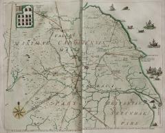
Plate 1.47: Engraving of a Plan of Roman Roads in Yorkshire
A map of most of the historic County of Yorkshire (as defined prior to the 1972 local government reorganization), although parts of the southern West Riding around Sheffield and the north-western extension of the North Riding west of Barnard Castle (County Durham) are missing. The latter area is occupied by a geographically inaccurate inset map derived from a manuscript version of the late Roman military and governmental list known as the Notitia Dignitatum. A number of areas outside the boundaries of the County are also included, including a substantial part of northern Lincolnshire.
The same plate was published by Francis Drake (1696-1771) in his Eboracum: Or the History and Antiquities of the City of York (1736, following page 36). However, the motivation for the initial production of Plate 1.47 is somewhat unclear; the version in Eboracum, while lacking the annotation in the upper right-hand corner that appears on the Vetusta Monumenta plate, bears the same dedication to the Society of Antiquaries of London (SAL). However, Drake’s Eboracum also acknowledges the support of the City of York and 540 subscribers. Unlike the Vetusta Monumenta version, the map as it appears in Eboracum is hand-tinted in color.
Object: Use Insert Scalar Link button (first one on the left above) to add link to relevant jpeg image. Choose size: medium. Choose align: right. Leave caption set to: description. Replace this text with commentary text describing the object, including its provenance and current location.
Transcription:To the Society of ANTIQUARIES in LONDON this Plate of the ROMAN Roads in the County of YORK &c is particularly inscribed by their Brother and very humble Servant FRANCIS DRAKE.
Commentary by Pete Wilson: The Society of Antiquaries of London (SAL) Minute Book for 27 November 1735 records that Francis Drake (1696-1771)
The balance of the evidence suggests that Drake produced the map and had it engraved at his own expense, but was reimbursed by the Antiquaries who published it in Vetusta Monumenta. Consequently, it is not possible to be certain who engraved the plate, which is unsigned, although Drake would have known George Vertue, the Society’s engraver, having been elected a Fellow on 27 February 1735.brought an Engraven Map of the Roman Roads in Yorkshire . . . which . . . [he] intends to dedicate to the Society” (SAL Minutes II.120). The minutes of the 25 March 1736 meeting record that “[t]he Secretary read a letter from Mr Drake, desiring The Society would be pleased to accept the Dedication of this map of the Roman Roads and Stations in Yorkshire. One of which he presented to them;…it was ordered that the Society, do make a present to Mr Drake of York of the expenses of the plate of his said Map,…[and] that Mr Drake be desired to deposit the said plate with the Society, after [he] has cast off a sufficient number for his own book. (SAL Minutes II.169)
Antiquarians, such as William Camden (1551-1623), have been interested in Roman Britain from at least the sixteenth century and have recorded and commented on Roman roads; although the earliest surviving reference to Roman roads in Yorkshire can be traced back to Ranulph Higden in 1344 (Babington 1889, 46). The first known attempt to map the Roman roads of Yorkshire was by John Warburton (1682-1759) as part of his Map of The County of York (1720), and it is likely that Drake borrowed from Warburton’s map but added his own information, such as his tracing of the road from Stamford Bridge to York (Drake 1736, 33-34). While presented as a map of Roman roads, the plate provides much additional information about Roman Yorkshire as understood at the time of its publication, although subsequent research has shown much of Drake’s understanding to be incorrect.
Features of roads on the map include: indications of the certainty of the roads’ existence, graded from certain (two unbroken lines) to less certain (combinations of lengths of unbroken lines and dotted lines) and uncertain or speculative (two parallel dotted lines); distances between some locations in units of mille passus (M.P.), that is 5,000 Roman feet or a Roman mile (1,480 meters or 4,856 feet); and unremittingly straight courses for most of the roads. Rivers are included and named, along with contemporary towns and smaller settlements which lie off the road system as shown, for example Richmond in the north west and Frydaythorp (contemporary Fridaythorpe) in the east. The influence of Drake and other antiquarians’ mapping of the roads carries through into later work, including that of Thomas Codrington 1905) and that of the doyen of twentieth-century Roman roads research, Ivan Margary, who established the accepted number systems for Roman roads in Britain (Margary 1955-57; 1967; 1973). The basic network of Roman roads illustrated is still recognizable in modern presentations of the system with significant groups of roads converging on key locations such as York, Malton and Aldborough (Margary 1973, map 17; Ordnance Survey 2016).
Major roads which are recorded on lines coincident, or very close to those accepted today, include that from Lincoln to the River Humber (Margary 1973, road 2d) and that from Isurium/Aldburgh (contemporary Aldborough) to Cataractonium/Catterick and on to Pierce Bridge (contemporary Piercebridge) and beyond (Margary 1973, roads 8b/8c). Roman-period names for the roads on Drake’s map are unknown. He labels the road north of Catterick ITER ad VALLUM, which means “Road to the Wall,” and refers to Hadrian’s Wall. The same road is also known to many antiquarians, such as Codrington (1905, 195-206) and MacLauchlan (1852), as Watling Street—one of several Watling Streets in Britain, with the best-known modern usage of the name being for the road from Dover to Whitchurch and Wroxeter (Margary 1973, road 1a-h). Codrington’s Watling Street, however, forms an extension of the Roman road he calls “Erming Street” (contemporary Ermine Street), which extends from London to Lincoln and on to York and Catterick. Codrington’s Erming Street incorporates two roads on Drake’s map: Iter A LINDO, approaching Danum/Doncaster from Lincoln, and ad EBOR from Castleford to LONGUS VICUS/Langburgh (contemporary Newton Kyme) and Tadcaster (Margary 1973, roads 28a-c). Drake’s road from York to Catterick through Aldborough is unnamed, but in contemporary usage is called Dere Street, and runs from York to Cramond in Scotland (Margary 1973, roads 8a-g). The name Dere Street derives from early medieval sources as the road to/from the Kingdom of Deira, which occupied eastern Yorkshire between the rivers Tees and Humber into the seventh century AD; afterwards, it became the southern part of the Anglo-Saxon Kingdom of Northumbria. In the twelfth-century History of St Cuthbert the road appears as Deorestrete (Bishop 2014, 39).
Research on Roman roads in Britain was unfashionable during the later decades of the twentieth century; other than when they were impacted by modern development, Roman roads were largely ignored by professional and university-based archaeologists. However, some of Drake’s “less certain” roads—such as his ITER a DEVA from Langburgh (Newton Kyme)/Tadcaster to Chester (Margary 1973, road 712)—have been the subjects of considerable research in recent years, particularly by the Huddersfield and District Archaeological Society (Lunn et al. 2008). This work makes it clear that Drake’s arrow-straight route is largely speculative. As might be expected, the Roman-period road builders— while often utilizing short stretches of straight alignments—took account of the challenging topography of the Pennines in identifying a viable route. Drake’s Strat a DEVA ad ISURIUM et VALLUM (Chester to Aldborough) is similarly straight, but while its route south of Ilkley is still incompletely known, it is clear that this route, too, would have wandered far from Drake’s line. For both roads it is instructive to compare Drake’s plate with contemporary data, such as the latter map on this page: the product of a recent initiative, namely, the formation of the Roman Roads Research Association (RRRA). The RRRA brings together researchers, still a largely avocational group, with a view of developing a better understanding of the Roman roads of Britain as a whole.
Drake’s “Certain Roads": Drake includes Ribchester on his map, despite the fact that it lies outside Yorkshire, and marks the site as a point of origin for two roads. The western road, Strata ad Vallum (Road to the Wall), extends to the northern edge of the map in another indicative, arrow-straight line. In reality, the road deviates to the east to negotiate a route through the uplands of the Forest of Bowland; to the north of Burrow in Lonsdale, the road stays on the east side of the River Lune in order to take advantage of the Tebay Gap to pass between the uplands of the Yorkshire Dales and the Lake District (Margary 1973, road 7c).
It is clear from examples such as these that Drake was not trying to offer anything approaching accurate mapping of the roads he illustrated. Instead, his map offers an indication of the roads’ broad directions. On the western side of the map, Drake’s Strata ad Vallum deviates away to the east from what appears be the River Lune as it extends north, whereas in reality the two get closer together, although they never quite converge. Similarly, his representation of his road ad LUGUVALLUM from Scotch Corner (unnamed on the map) to Carlisle (located off the map to the northwest) would meet his Strata ad Vallum at roughly the correct latitude in relation to the Tees Estuary on the eastern side of the county, although it incorporates a change of alignment on Gatherly (contemporary Gatherley) Moor and appears to be projected on a straight line west of there, taking no account of the topographical challenges presented by Stainmore and the upper Eden Valley.
Drake’s attention to topography and geography in Yorkshire is scant. Perhaps Drake was constrained by the limitations on the period’s surveyors, although logarithmic tables and portable angle-measuring instruments had been available from the first half of the seventeenth century. His road from Malton to Burlington (Bridlington) passes through Sledmere and close to Wharram-le-Street, with Sledmere, incorrectly, located to the north of the latitude of Wharram-le-Street. Contemporary scholarship has a road extending eastwards from Malton towards Bridlington (Margary 1973, road 812), but with the course being traced for no more than six kilometers. That said, recent reconsideration of the previously unlocated Praetorio of Iter I of the Antonine Itinerary, a Roman-period road book, suggests that the name should be applied to a lost Roman-period port in the vicinity of Bridlington (Wilson 2017a). This would suggest that there should be a road from the preceding place in the Itinerary which is argued to be Malton (see below). The name of Wharram-le-Street suggests a location on a Roman road (Cameron 1977, 194-203; Gelling 1978, 153), but the road in question is more likely to be a possible north-south road extending southeast from Malton (Margary 1973, road 813), and not the west-east road to Bridlington. Drake’s road from Malton to Brough, which he regards as uncertain north of Londesburgh (contemporary Londesborough), is now seen as doubtful for the bulk of its length. The accepted route of road Margary 29 is to the east of Londesborough and, to the north of South Newbald, the route of Margary road 2e is to the west. The Londesborough area, as currently known, has not produced any evidence of substantial Roman-period settlement.
Drake and Lord Burlington: In the list of subscribers to his Eboracum, Drake gives particular prominence to Lord Burlington, who had intervened on his behalf after he was unjustly imprisoned for debt (Barr 2004). Lord Burlington had his seat at Londesborough as Baron Clifford, and it is possible that Drake’s placing of a major crossroads was an attempt to flatter his savior; the map shows Drake’s Brough to Malton road intersecting with his Stamford Bridge to Spurn Point Roman road at Londesborough. The same is presumably true with regard to Drake’s replacement of the modern name Bridlington with Burlington given that the development of the Domesday version of the place-name, Bretlinton, is readily philologically traced to Bridlington; there’s no evidence of a Burlington variation (Smith 1937, 100-02).
Drake’s “Uncertain” or “Speculative” Roads: As noted above, some of Drake’s “less certain” roads have been investigated by researchers in the twentieth century and also more recently. Modern scholarship has confirmed the existence of Drake’s road from York to Stamford Bridge as the western end of Margary (1973) road 810 (Haken 2018a). Drake’s York to Malton road has been accepted as “possible” (Haken 2018b); the best evidence for the road’s existence is to be found between York and Stockton-on-the-Forest (Margary 1973, road 800). In contrast, the road that Drake projects from York to the Tees Estuary—which runs through Newburgh and climbs over the Hambleton Hills and the western side of the North York Moors, where it could incorporate the Hambleton Street drove road as a possible element—finds no support in modern scholarship. In functional terms, the road, as suggested by Drake, would have been rendered superfluous by the existence of Cade’s Road (Margary 1973, road 80a), located to the west of the North York Moors on much less challenging terrain.