
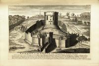
Plate 1.46: Tickhill Castle
Object: The plate shows the medieval castle of Tickhill Castle in South Yorkshire, based on a drawing completed in 1561 when Ambrose Cave, chancellor of the Duchy of Lancaster, ordered it to be surveyed along with the other properties of the duchy. Besides the castle, dominated by the imposing motte topped by the keep, and a number of buildings inside the castle’s bailey, the plate also shows houses and churches most likely belonging to the parishes of Tickhill and Laughton-en-le-Morthen, two watermills and mill dams, one windmill, two forests, a pair of resting cows and three rustic figures, a rider leading two spare horses, a man walking towards the watermill to the right of the plate, and two touring antiquaries with a horse in the foreground.
The oldest remains of Tickhill castle date to the late eleventh century. During this period, an older timber castle— erected as a Norman stronghold in the eleventh century—was rebuilt in stone. The gatehouse and part of the curtain wall were constructed under Henry I in the early twelfth century. Towards the end of the twelfth century, Henry II invested considerable sums in the improvement of Tickhill Castle’s fortifications; he ordered the eleven-sided keep, a new stone bridge, and a new curtain wall to be built. The castle was periodically repaired over the next centuries, but it was only in the early seventeenth century that substantial building activities took place once more when Sir Ralph Hansby leased the castle from James I. The castle served as royalist garrison during the Civil War, but was surrendered in 1646 and demolished on the order of parliament soon afterwards (Hey 2003, 70-71). Today, parts of the castle grounds and Tickhill Castle House (a large hall built within the courtyard of the castle after the Civil War) are leased to a private tenant. The remains of the medieval castle—the motte, the foundations of the keep, parts of the curtain wall and of the gatehouse—are open to the public once per year.
Transcription:
TICKHILL an Old CASTLE near Doncaster in YORK-SHIRE. / Surrounded with a single Wall only, and in the Middle a large Mount, on the Top of it a round Tower. William ye Conqueror gave it to Roger de Buisly with 49 Mannors in this Shire; it was of such Dignity (in old Times) that all the Mannors round belonging to it were stiled the HONOUR of TICKHILL. K. Henry 1.st seized upon this Honour of Tickhill, and other succeeding Kings did the like, this having been several times in the Crown, was by K. Edward ye 3.d (Pat.46.E.3.m.35.) given to John of Gaunt Duke of Lancaster, from whom it pass’d to the Crown by the Succession of his Son K. Henry 4.th and has remain’d in the Dutchy ever since. Sumpt. S: Ant. Lond. 1737.
Preparatory Drawings: Click here to see the Preparatory Drawings for Plate 1.46.
Commentary by Katharina Boehm: This print completes the series of six plates based on Elizabethan drawings and featuring castles belonging to the Duchy of Lancaster, which were included in the first volume of Vetusta Monumenta (two additional plates showing castles of the duchy were included in Volume II, see Plates 2.11 and 2.13). Like the other duchy castles, Tickhill Castle belonged to the crown for large parts of its existence. However, unlike castles such as Pontefract, Knaresborough, and Lancaster, Tickhill Castle had rarely served as setting for cataclysmic historical events and had, therefore, received little attention from antiquaries. In the early 1730s, when the members of the Society of Antiquaries of London (SAL) tasked George Vertue with the production of this print, information about the castle’s history could be found in the duchy’s records, but little of this information had found its way into printed sources. Prior to Vertue’s engraving, there appear to have been no prints of Tickhill Castle in circulation. Not even the prolific Samuel Buck (1697-1779), who stopped near Tickhill to draw the ruin of Roche Abbey in 1725, made time for what remained of the medieval castle at this point: the dramatic motte and the foundations of the keep, parts of the gatehouse, and the curtain wall (Buck 1725).
William Camden’s (1551-1623) Britannia evidently informed the Society’s discussion of Tickhill Castle; Camden’s short description of the castle and account of its history are echoed in the text printed on the plate. Camden’s description of Tickhill begins, “an old castle, which is large, but only surrounded with a single wall, and by a huge mount with a round tower on the top of it. It was of such dignity heretofore, that all the manours hereabouts appertaining to it, were stil’d, the Honour of Tickhill” (1722, 850). The Honour of Tickhill (now usually referred to by historians as the Honour of Blyth-Tickhill), which is also mentioned in the text on the plate, was newly formed after the Norman Conquest and comprised a belt of land extending across the northern part of Nottinghamshire and into Yorkshire, framed by the Humberhead marshes to the east and the Pennines to the west. Roger de Busli, the Norman Baron who fought alongside William the Conqueror and became the first owner of the newly generated Honour, built the first timber castle of Tickhill and turned it into the military and administrative center of the Honour (Creighton 2002, 107).
The few eighteenth-century domestic tours and travelogues that mention Tickhill Castle—for instance, in the expanded 1742 edition of Defoe’s Tour thro’ the Whole Island of Great Britain—give their readers a lightly paraphrased version of Camden’s account (Defoe 1742, 3.99). Perhaps the very scarcity of available print sources on Tickhill’s history made it seem all the more worthwhile to the SAL to fund a modern reproduction of the sixteenth-century drawing, which measures 40.5 x 58.5 cm and is now held by The National Archives (TNA MPC 1/96). They might also have been struck by the fact that the original drawing is one of only two drawings from the original cache to provide a visual record of the mills and milldams which Ambrose Cave examined as part of his survey of the duchy castles and properties in 1561 (Hoyle 1992, 42-43). Of the six prints in the series included in Volume I of Vetusta Monumenta, this plate stands out for its attention to the agricultural resources of Tickhill and its environs. Tickhill was known for the quality of its soil: John Leland, who passed through Tickhill just a few decades before the sixteenth-century drawing was made, described the “grounde […] fruteful of corne” (Leland 1907, 1.35).
Following the design of the original drawing, Vertue’s print shows several buildings inside the castle’s bailey, including the twelfth-century chapel dedicated to St Nicholas founded by Eleanor of Aquitaine, Henry II’s queen. Similar to Plate 1.41 of Lancaster Castle, Vertue eradicated the densely packed rows of very small and uniform houses which cover two hills in the foreground of the original drawing and which seem to have been intended to signify the proximity of the town of Tickhill rather than to represent specific historical buildings. The print reproduces two churches, surrounded by neighboring buildings, which are also part of the original drawing. The church with the high steeple visible on a hill in the background resembles Laughton-en-le-Morthen’s famous All Saints’ church, which could be seen from the motte of the castle, though not from the location from which the perspective view was taken (Grainge 1855, 8). The other church to the right of the castle probably depicts St Mary’s, the parish church of Tickhill. The location is incorrect, but the sixteenth-century draughtsman took similar liberties when he produced the other drawings, and there was no other church or abbey in the direct vicinity of the castle in the sixteenth century. The history of St Mary’s is closely linked to the castle’s history: it was rebuilt in stone in the twelfth century at roughly the same period when the first timber castle of Tickhill was fortified and rebuilt in stone (Standish 1905, 19-20).
Vertue’s approach to his source material is fairly consistent across the set of plates depicting duchy castles: in this print, as in the others, he included all major buildings shown in the original but increased the symmetry of the composition by adding a partly cloudy sky. Using fine gradations of shading allowed Vertue to add considerable depth and dimension to the castles, which are primarily presented in outline in the sixteenth-century drawings with only occasional use of light shading. The range of grey tonalities Vertue achieved gives rich texture to the various parts of the castles and to the surrounding landscape. However, Vertue rarely made attempts to correct the perspectival oddities and scale issues of the original drawings. The plate of Tickhill castle—like the other plates that were part of the duchy castle series—replicates the faulty perspective of the original, as is evident, for instance, in the implausible angle at which the stone bridge spanning the moat juts out. Another case in point is the oversized watermill to the left of the castle: although positioned further in the distance, this windmill is considerably bigger than the watermill closer to the foreground to the right of the castle; it also dwarfs the group of houses half hidden behind the motte inside the castle’s walls. The sixteenth-century artist’s brief was to provide a visual inventory of duchy properties. “Defects” in perspective and scale were probably at times occasioned by haste and lack of skill, but they also speak to the artist’s priorities: illustrating the state of repair of the famous stone bridge, built under Henry II and Eleanor of Aquitaine, clearly trumped aesthetic concerns; similarly, the size of the watermill might well have reflected the relative importance and yield of this particular mill.
The SAL minutes do not offer any clues to Vertue’s and the other SAL members’ understanding of the original drawings. However, it seems likely that two factors contributed to Vertue’s decision to adopt the perspective found in the originals in his engravings. First, while the perspective in which the duchy castles are drawn is obviously faulty, introducing changes and corrections would have required information about the architectural design and layout of the castles that was no longer available in the early eighteenth century, because most of the duchy castles had been demolished after the Civil War. (Tellingly, Vertue did introduce an error when he attempted to correct and enhance the sixteenth-century artist’s rendition of Lancaster castle’s Norman keep, discussed in the commentary for Plate 1.41.) Even if Vertue had been able to travel north and survey the ruins—which he did not do—he would have found it impossible to discern many architectural details from the ruins that remained. The scarcity of other visual sources on the former appearance of many of these castles thus may well have contributed to the Society’s desire to preserve the entirety of the archaeological information provided by the surviving drawings, even if this information was often presented in a manner that violated the rules of perspective.
Second, Vertue’s handling of perspective and scale also intriguingly suggests that the members of the SAL might have understood these fairly unsophisticated Elizabethan drawings, produced by an unknown artist, not just as neutral medium providing information about the duchy castles but as artifacts in their own right. Vertue was skilled at engraving paintings; in fact, one of the earliest plates he produced for the SAL was a print based on a drawing of a late fourteenth-century portrait of Richard II (Plate 1.4). For Vertue, awareness of shifting aesthetic conventions and gradual changes in the manner in which artists paid attention to perspective was not merely a matter of abstract knowledge but part of his practice as engraver and antiquary. His approach to the duchy castle series indicates that the members of the SAL might have found it worthwhile to preserve the perspectival strangeness characteristic of visual representations from the Elizabethan period, even as they seem to have welcomed Vertue’s addition of picturesque details and staffage which increase the plates’ perceived resemblance to early eighteenth-century topographical prints.
Vertue’s removal of the townscape that fills the bottom margin of the Elizabethan drawing adds to the idyllic rural character of this view of Tickhill Castle and its three mills. In analogous fashion to his insertion of bucolic features into Plate 1.44 showing Knaresborough Castle, Vertue also added features that heighten the picturesque character of the environs of Tickhill Castle. He replaced the tightly packed rows of houses that cover the two hills in the foreground in the original drawing with pastures and a gently winding footpath. Two cows rest on the grass, lazily guarded by a trio of cowherds, while a rider leads two horses past the castle. Vertue positioned two traveling, modern-day antiquaries in the bottom right corner of the plate. These men serve as proxy figures for the viewer: they turn their backs to us in order to gaze at the castle and the fertile working landscape that surrounds it. Just like the antiquaries in the engraving, a number of members of the SAL toured parts of the country on horseback during the summer months to survey antiquities; Vertue’s immediate audience must therefore have had little difficulty in inserting themselves into this picture. Indeed, the text given on the plate does nothing to dispel the fantasy that modern-day antiquaries might still be able to explore Tickhill Castle firsthand; no information is given regarding the ruined state of the castle, and neither does the text alert the viewer to the fact that the engraving is based on a sixteenth-century drawing.
The plates of the duchy castle series are inconsistent in the manner in which they refer to their sources: the texts given on the first two plates finished by Vertue, showing Tutbury Castle (Plate 1.39) and Melbourne Castle (Plate 1.40), state that the engravings are based on drawings from the reign of Elizabeth I; the plate of Knaresborough Castle merely states that the print is based on an “old draught” (Plate 1.44); and the plates of Pontefract Castle (Plate 1.42) and Tickhill Castle (Plate 1.46) include no information about the sources used by Vertue. Viewers who encountered these plates as a sequence in the context of Vetusta Monumenta could easily deduce that Vertue’s view of Tickhill Castle, too, was based on a sixteenth-century drawing. However, the plates were first distributed individually, and someone who came across a single print of Tickhill Castle in the 1730s with no background knowledge about the genesis of the plate series might have experienced an odd sense of temporal incongruity: after all, the plate merges an Elizabethan approach to perspective and scale with a nascent penchant for the picturesque and inserts two contemporary antiquaries who admire a castle that no longer exists.
Vertue’s entire duchy castles series restored important medieval castles, many of which had long been demolished and had largely vanished from the landscape they had once dominated. Much like their seventeenth-century colleagues, mid-eighteenth-century antiquaries understood the restoration of British antiquities as a project that required the action of pen, paper, and print, rather than the physical conservation or rebuilding of antiquities. Long before late-eighteenth-century antiquaries and architects began to clash over the respective virtues of physically restoring or “improving” historical buildings, this generation of antiquaries was mostly content with translating crumbling medieval ruins and disintegrating Roman pavements into detailed drawings, maps, and dissertations. The duchy castle series as a whole—and Vertue’s print of Tickhill Castle in particular—thus offer a lively demonstration of one of the key aims that the SAL pursued with Vetusta Monumenta: these plates pay testament to the resurrective powers of visual representation and print technologies. Some of the buildings and objects represented in Vetusta Monumenta were damaged further, or lost entirely, in the decades and centuries following its publication. In the case of the duchy castles, however, this moment of physical destruction was long past; instead of anticipating the demolition of these imposing medieval castles, members of the Society could insert themselves into the antiquarian dreamscape of Vertue’s multi-temporal engravings and see these castles rise again in paper form.
Works Cited:
Buck, Samuel and Nathaniel Buck. (1725) 1774. “The West View of Roche-Abbey, near Tickhill in Yorkshire.” In Buck’s Antiquities. Vol. 1. London: Sayer.
Camden, William. 1722. Britannia, or a chorographical description of Great Britain and Ireland, together with the adjacent islands. Translated by Edmund Gibson. Vol. 2. London: Mary Matthews.
Creighton, O.H. 2002. Castles and Landscape: Power, Community and Fortification in Medieval England. London: Equinox.
Defoe, Daniel. 1742. A Tour thro’ the Whole Island of Great Britain. 3rd ed. 4 vols. London: J. Osborn et al.
Grainge, William. 1855. The Castles and Abbeys of Yorkshire. York: Sampson.
Hey, David. 2003. Medieval South Yorkshire. Ashbourne: Landmark.
Hoyle, R.W. 1992. “Introduction: Aspects of the Crown’s Estate, c. 1558-1640.” In The Estates of the English Crown, 1558-1640, edited by R.W. Hoyle, 1-57. Cambridge: Cambridge University Press.
Leland, John. 1907. The Itinerary of John Leland in or about the years 1535-43. Edited by Lucy Toulmin Smith. 5 vols. London: George Bell.
Society of Antiquaries of London. 1718-. Minutes of the Society’s Proceedings.
Standish, John. 1906. “Rev. J. Standish’s Paper” [The History of St. Mary’s, Tickhill]. In Transactions of the Thoroton Society, Vol. IX, edited by John Standish and George Fellows, 19-27. Nottingham: Thoroton Press.
Tykehill: Perspective View of Tickhill Castle. 1561. MPC 1/96. The National Archives, Kew.