
Creative Commons Attribution-Noncommercial-No Derivative Works 3.0
Plate 1.8: Engraving of a Plan of the Roman Walls and City of Verulamium
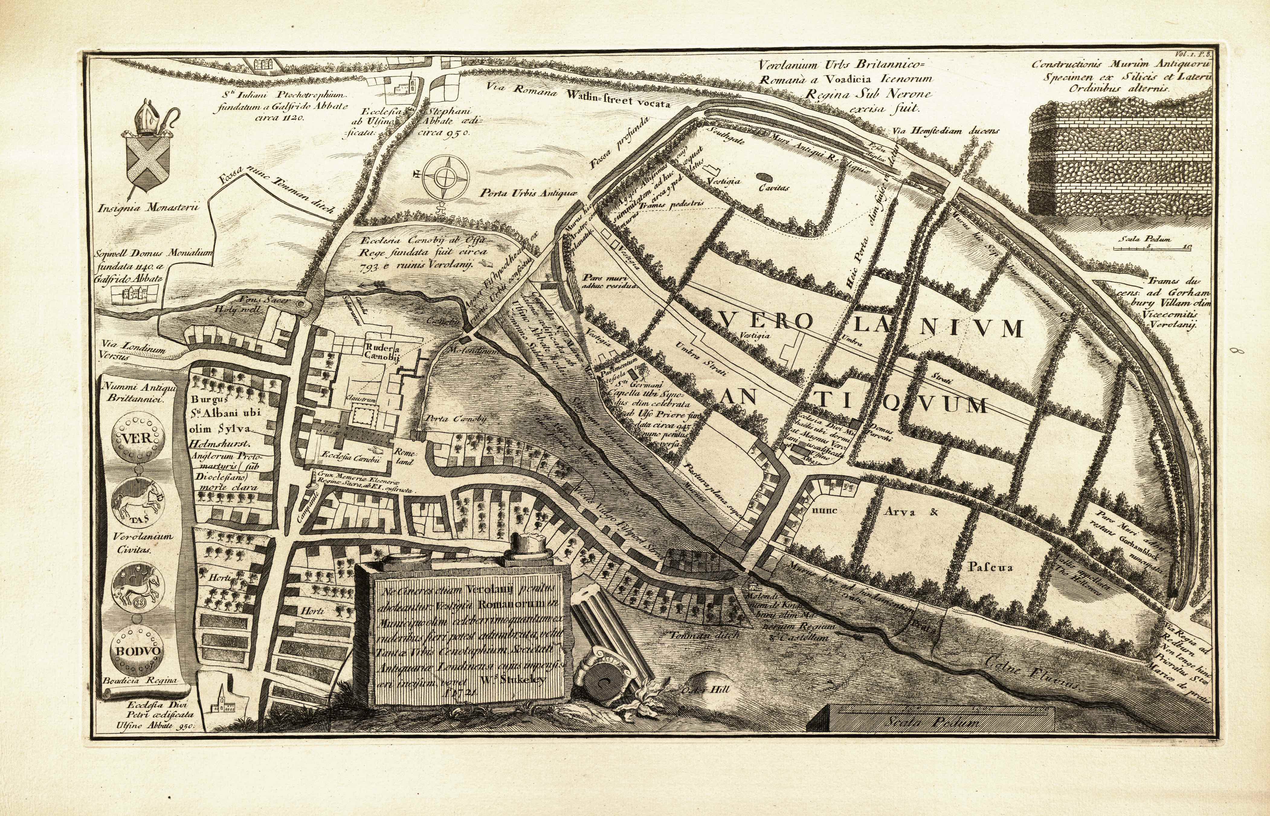
1 2018-08-29T11:35:45+00:00 Crystal B. Lake b7829cc6981c2837dafd356811d9393ab4d81adc 31 4 Plate 1.8 of Vetusta Monumenta features an extensively labeled map of the Roman remains of Verulamium with inset images of two ancient British coins and a section of Roman wall. Engraving by George Vertue after William Stukeley. Published by the Society of Antiquaries of London in 1721. Current location: Stukeley’s original map is preserved at the Society of Antiquaries of London; the Roman ruins today are encompassed by the modern city of St. Alban’s in Hertfordshire, UK. plain 2019-06-07T08:59:15+00:00 Crystal B. Lake b7829cc6981c2837dafd356811d9393ab4d81adcThis page has paths:
- 1 media/vm1-02.jpg 2018-05-15T17:37:03+00:00 Craig Dietrich 2d66800a3e5a1eaee3a9ca2f91f391c8a6893490 Volume 1, Plates 1 — 26 Noah Heringman 7 plain 2019-05-24T15:37:33+00:00 Noah Heringman ed5eca6418903b1281787a0c30645d943ca84184
This page is referenced by:
-
1
2018-08-28T17:05:18+00:00
Plate 1.8: Plan of Ancient Verulamium
19
Scholarly Commentary with DZI View for Vetusta Monumenta, Plate 1.8. Commentary by Noah Heringman and Katherine Hobbs.
plain
2019-09-30T10:35:16+00:00
Plate: Engraved by George Vertue (1684-1756) after William Stukeley (1687-1765) in 1721.
Object: An extensively labeled map of the Roman remains of Verulamium with inset images of two ancient British coins and a section of Roman wall. The Roman ruins today are encompassed by the modern city of St. Alban’s in Hertfordshire. Stukeley’s original map is preserved at the Society of Antiquaries of London.
Transcription:
Click here to access an interactive map providing full transcription and translation details for Plate 1.8.
Upper Left Quadrant:
Sti Iuliani Ptochotrophium fundatum a Galfrido Abbate circa 1120
Ecclesia Stephani ab Ulsino Abbate aedificata circa 950
Via Romana Watlin Street vocata
Insignia Monasterii
Fossa nunc Tonman ditch
Porta Urbis Antiquae
Fossa profunda
Sopwell Domus Monialium fundata 1140 a Galfrido Abbate
Fons Sacer
Canalis Subteraneus
Ecclesia Caenobii ab Offa Rege fundata fuit cicra 793 e ruinis Verolanii
Agger Fishpoolhead ex ruinis Urbis confectus
Capella Stae. Mariae Magdalenae aedificata ab Ulfino Abbate hodie omnino Sublata.
Murus hic Aratro c[u]m planatus.
Pars muri adhuc residua
Vestigia
Agger Altissimus cuius summitatem adhuc aequat murus circa 9 ped. latus.
Via Londinum Versus
Rudera Caenobii
Caenobii Molendinum
Burgus St Albani ubi olim Sylva Holmshurst Anglorum Proto-martyris (sub Dioclesiano) morte clara
Upper Right Quadrant:
Verolanium Urbs Britannico-Romana a Voadicia Icenorum Regina Sub Nerone excisa fuit.
Via Hemstediam ducens
Constructionis Murum Antiquorum Specimen ex Silicis et Laterum Ordinibus alternis.
Southgate
Fossa duplex
Muri Antiqui Reliquiae
Cavitas
Trames pedestris
Huic porta olim fuisse videtur
Murus hic Sepibus coronatur Sat tamen conspicuus
Scala Pedum
Trames ducens ad Gorhambury Villam olim Vicecomitis Verolanii
Vestigia
Umbra Strati
Vestigia
Pavimentum tesselatum
Sti Germani Capella ubi Synodus olim celebrata ab Ulfo Priore fundata circa 945 nunc penitus versa.
VEROLANIUM ANTIQUUM
Left Banner: Nummi Antiqui Brittannici / Verolamium Civitas / Boadicia Regina [Ancient British Coins / City of Verolamium / Queen Boudica]
Bottom Left Quadrant:
Claustrum
Porta Caenobiij
Stagnum olim desiccatum ab Alfirico Abbate circa 960 nunc prater
Ecclesia Caenobii
Rome Land
Campanale
Crux Memoriae Eleonorae Reginae Sacra ab E.I exstructa
Vicus Vulgo Fishpool Street
Ecclesia Divi Petri aedificata Ulsino Abbate 950
Horti
Ne cineres etiam Verolanii penitus aboleantur: Vestigia Romanorum in Municipio olim celeberrimo quantum ex ruderibus fieri potest adumbrata, velut Tantae Vrbis Cenotaphium Societati Antiquariae Londinensi cujus impensis aeri incisum, vovet. W. Stukeley. Anno 1721
Bottom Right Quadrant:
Ecclesia Divi Michaelis ubi dormitat Magnus Verolanius; aedificata ab Ulsino Abb, 950.
Domus parochi
Pastura plana super murum
Nunc Arva & Pascua
Pars Muri adhuc restans Gorhamblock nuncupata.
Vallis appellata “The Hollowes”
Tonman Ditch
Molendinum de Kingsbury olim Manerium Regium & Castellum
Murus heic ad fundamentum erutus
Prata
Colne Fluvius
Via Regia ad Redburn Non longe hinc Prioratus Stae Mariae de pratis. [Royal Road to Redbourn.
Oster Hill
Scala Pedum
Translation:
Click here to access an interactive map providing full transcription and translation details for Plate 1.8.
Upper Left Quadrant:
St. Julian’s Almshouse founded around 1120 by Abbot Geoffrey
St. Stephen’s Church, built by Abbot Wulsin around 950.
Roman road, called Watling Street
seal of the Monastery
a trench, now Tonman ditch
ancient city-gate
a deep ditch
Sopwell Priory which was founded in 1140 by Abbot Geoffrey [de Gorham]
Holy Well
underground canal
The Monastery Church was founded by King Offa around 793 from the ruins of Verolamium.
Fishpoolhead Rampart / Causeway made from the ruins of the city
Chapel of St. Mary Magdalene, built by Abbot Wulsin; today it is entirely submerged.
This wall was flattened by a plough.
A part of the wall that still remains.
remnants
An enormous pile, whose surface still equals a 9 foot wall.
the road toward London
ruins of the abbey
monastery’s mill-house
City of St Alban’s where there was once a Forest, Holmhurst [Holywell Hill], famous for the death of the first Martyr of England under Diocletian.
Upper Right Quadrant:
A British-Roman City, Verulamium, which was destroyed by Boudica, Queen of the Iceni during Nero’s reign.
A road leading to Hempstead.
A model of an ancient city wall, made out of alternating rows of brick and flint.
Southgate
a double ditch
relics of the ancient wall
a hollow
footpath
A gate appears to have been here once.
The wall is surrounded by hedges and yet is sufficiently visible.
scale of feet
A footpath leading to Old Gorhambury House, which belonged to the Earl of Verulam.
remnants
covered by shade
remnants
tessellated pavement
Chapel of St. Germanus [of Auxerre] where a Synod was once gathered. The chapel was established by Ulf, Prior [of St. Albans] around 945. It is now entirely changed.
Ancient Verulamium
Left Banner: Ancient British Coins / City of Verolamium / Queen Boudica
Bottom Left Quadrant:
cloister
abbey gate
Stagnant water, which was once drained by Abbot Aelfric around 960, now a meadow.
St Alban’s Abbey Cathedral
Rome Land
bell tower
Cross Sacred to the Memory of Queen Eleanor, built by Edward I.
a street, commonly known as Fishpool Street
Church of St. Peter, established by Abbot Wulsin
gardens
Let the ruins of Verolamium not be entirely obliterated: The Roman remains in the once celebrated town can be drawn as much as possible from the ruins, like a cenotaph of the city. In the year 1721 William Stukeley dedicated himself to engraving it in copper at the expense of the Society of Antiquaries of London.
Bottom Right Quadrant:
St. Michael’s Church, where Great Verulamium rests. It was established by Abbot Wulsin around 950.
Parish house
a flat pasture above the wall
now fields and pastures
Part of the wall that is still standing, called Gorhamblock.
a valley called “The Hollows”
Tonman Ditch
the Kingsbury Watermill, formerly King’s manor and fortress
The wall was here destroyed to the foundation.
meadows
River Colne (or Ver)
Royal Road to Redbourn. The Priory of St. Mary’s is not far from these meadows.
Oster Hill
scale of feet
Commentary by Noah Heringman and Katherine Hobbs: This plate shows a map of the ruined city of Verulamium in Hertfordshire, originally drafted and annotated by William Stukeley on a visit to the site in 1721. Verulamium, a municipium under Roman rule that had earlier been occupied by Britons, was subject to a series of wars and invasions, eventually becoming the town of St. Albans upon the construction of a Benedictine monastery in the 790s A.D. The abbey was built to honor the saint, who was England’s first martyr (Bohun 1710, 8; Heylyn 1709, 195). Verulamium is notable for having been controlled by many different groups over time and has connections to several important episodes in British history. The subject thus affords an opportunity for Stukeley to display both classical erudition and zeal for British antiquities in the same compass.
Verulamium was a wealthy city, and was the site of a mint even before the Roman invasion in the first century A.D. (“Some Account” 1783, 132). Eighteenth-century accounts such as John Collinson’s Beauties of British Antiquity noted the “several pieces of ancient money” found at Verulamium; these seem to match the coins illustrated on the map. The coins were observed to have the inscription “TASCIA” engraved on one side and “VER” on the other, signifying, according to this author, “the tribute of Verulam” since “Tasc, in the British tongue, signifies tribute” (Collinson 1779, 79). In fact, this inscription may refer to the Catuvellauni leader Tasciovanus. A traveler’s account included in the Annual Register for 1782 notes coins from the “British mints” containing “the word Ver… but no prince’s name to distinguish the reign,” linking them speculatively to the reign of “Cunoboline [a pre-Roman leader], whose coins are so frequent” (“Some Account” 1783, 132).
The town’s wealth made it appealing to invaders, one of whom was Boudicca, queen of the Iceni, who led a revolt in 60-61 A.D. An eighteenth-century account of the abbey, drawing on Tacitus for its account of this revolt against Roman occupation, declares that Verulamium was “rich and opulent[,]… a greater temptation to a plundering foe than mere castles and military posts” (Newcome 1795, 3). Boudicca’s assault receives much attention in eighteenth-century accounts; the appearance of her name reinforces the importance of this episode for the study of British antiquities. John Gifford’s History of England details Boudicca’s ill-treatment by the Romans in quasi-patriotic terms to justify her violent destruction of the Roman city. This queen of “dignified deportment” and “magnanimous spirit” roused the “flame of indignant virtue” in the Iceni and other groups of Britons (Gifford 1790, 1.19). Although not all accounts are so sympathetic to Boudicca’s cause, the destruction of Verulamium as a symbol of Roman rule is presented here as important in regaining lost British dignity.
The ancient site, labeled in large capitals, occupies a large proportion of the map and attracted the keen interest of many eighteenth-century observers. The wall, the outline of which is shown winding around the ancient city, seems to have been an impressive manifestation of Roman defenses. The writer whose travel account is included in the Annual Register for 1782 notes that these Roman walls were added onto pre-existing defenses of ditches and ramparts, an observation that exemplifies the merging of different layers of political and cultural influences on the site of Verulamium. He also observes that the area (once) enclosed within the wall is peculiar for being oval-shaped and “depart[ing] from the Rectangular form of the Romans.” It is “placed on a slope, and the other side bounded by the river Ver, which in former times might have… given greater security to the town” (“Some Account” 1783, 131). The construction of the wall is illustrated in detail in the upper-right hand corner, corresponding to the Annual Register's description of the twelve-foot-thick walls, arranged so that “By intervals of abo[ut] three feet distance, are three, and in some places four, rows of bro[ad] and thin bricks…which seem design[ed] as foundations to sustain the layers of flints and lime” (132). This 1782 account draws not only from the writer’s personal observation but from the present engraving of Stukeley’s map; the writer cites Stukeley’s measurement of Verulamium’s dimensions and in a note refers to his “admirable plan” of the city (132).
In the eighteenth century, the area formerly within the Roman walls was “inclosed into fields” (“Some Account” 1783, 133), as portrayed on the plate. The same account notes that as the fields were being tilled, the ancient streets were revealed along with various artifacts under the hedges. The most notable was Watling-Street, a major road running all the way “from Dover into the north,” which was the source of the Saxon name of for Verulamium, Watlingcester (Geography 1744, 80). By juxtaposing the modern hedges with the ancient grid of streets, Stukeley’s map hints at the complex relationship between the “improvement” of land and the conservation of antiquities that is given pictorial form in other engravings in Vetusta Monumenta.
Verulamium / St. Albans also marks the site of intersecting religious traditions, residing at a symbolic juncture between the pagan past and the rise of Christianity. The first English martyr, Saint Alban, was beheaded on Holmhurst Hill in the fourth century A.D. The Annual Register account describes St. Alban’s martyrdom at length, detailing some of the associated legends; according to this story, the executioner’s eyes fell out and a fountain sprang up, while a river that had been separating Holmhurst and Verulamium dried so that Alban’s followers could cross (“Some Account” 1783, 133). Alban’s supposed remains were found by Ossa, King of the Mercians, who founded a Benedictine monastery on the site in the 790s (“Some Account” 1783, 134; Bohun 1710, 8). The site of the monastery had held an earlier church that was destroyed in wars between the Britons and Saxons (Heylyn 1709, 195). The new abbey church was built partially from old Roman materials found around the area; Collinson notes that the “ancient part [of the Church of St. Alban] and the steeple are built entirely of Roman brick, fetched by the abbots from the old city” (Collinson 1779, 80). The new monastery became the basis for the town of St. Alban’s, and the abbot of St. Alban’s was, according to Peter Heylyn, given “precedency of all English abbots” by virtue of Alban’s position as the first English martyr (Heylyn 1709, 195).
The abbey was surrendered to Henry VIII in 1539 during the Dissolution of Monasteries, but the abbey church survived and was subsequently converted to a parish church (Heylyn 1709, 195-196). By this point, Verulamium was a place of conflicting identities, as is evident in The Ruines of Time, a poem written by Edmund Spenser in 1591, relatively soon after the harsh episode of the Dissolution. In the poem, Verulamium, or Verlame, personified as a woman, is presented as “sorrowfullie [be]wailing” the unstoppable effects of time, lamenting that she once “the garland wore / Of Britaines pride” but now must “lye in [her] owne ashes” (Spenser [1591] 1989, lines 233-34). Having seen so much change and destruction over time, Verulamium aptly illustrates Spenser’s thesis that built monuments all eventually fall to ruin, and true longevity only comes from the written word. Scholars have noted that this poem is “informed by the Tudor destruction of the medieval Catholic past” and reflects the tensions present in the early years of English Protestantism, tensions resulting from the need to acknowledge that Early Modern Britain was built on a pagan and Catholic past and to reconcile the Protestant present with this past (Prendergast 2008, 178; cf. Melehy 2005). Stukeley and his collaborators, who consciously revived the Elizabethan Society of Antiquaries, has the benefit of historical distance in grappling with these tensions. Hence this map celebrates the rich historical texture created by religious and political conflict while also promising an enlightened overcoming of these differences.
Although Spenser’s Verlame admonishes her hearers that built works must, “as a vapour[,] vanish and decaie” (line 56), the city’s physical remains as of 1721 still bore abundant witness to many centuries of violence and transition. Some of the Roman remains have been repurposed, rather than “vanishing,” as noted by the eighteenth-century commentators who took interest in the use of Roman bricks to build a Catholic monastery and the subsequent conversion of this same abbey to a Protestant church. Each phase had built physically on the last, which is evident in Stukeley’s rendering of the city, containing items ranging from Roman walls to a cross built by Edward I in 1291 to the eighteenth-century town of St. Albans. Stukeley’s engraving celebrates the coexistence of the diverse historical layers that make up Verulamium. Clearly, even if Spenser’s Verlame insists that “vaine moniments of earthlie masse” ([1591] 1989, line 419) are no match for the longevity of “wise wordes… / Recorded by the Muses” (lines 402-03), the physical site itself and the historical traces left behind in pieces of walls, evidence of roads, and excavated coins proved to be more and more intriguing for antiquaries in the centuries following Spenser; many of these remains, in fact, came to light only after Spenser’s time. By the time Vertue engraved Stukeley’s map in 1721, Verulamium could be seen to display many layers of historical resonance, all contributing to its—and by extension Britain’s—unique identity in the present.
Works Cited:
Bohun, Edmund. 1710. A Geographical Dictionary. London: R. Bonwicke, et al.
Collinson, John. 1779. The Beauties of British Antiquity; Selected from the Writings of Esteemed Antiquaries. London: John Collinson.
Gifford, John. 1790. The History of England, from the Earliest Times to the Peace of 1783. 2 vols. London: Harrison.
The Geography of England. 1744. London: R. Dodsley.
Heylyn, Peter. 1709. A Help to English History. London.
Melehy, Hassan. 2005. “Antiquities of Britain: Spenser’s Ruines of Time.” Studies in Philology 102, no. 2: 159-183.
Newcome, Peter. 1795. The History of the Ancient and Royal Foundation, Called the Abbey of St. Alban. London: J. Nichols.
Prendergast, Thomas A. 2008. “Spenser’s Phantastic History, The Ruines of Time, and the Invention of Medievalism.” Journal of Medieval and Early Modern Studies 38, no. 2: 175-196.
“Some Account of the Antient Verulamium, near St. Albans—of its Ruins, &c.” 1783. In The Annual Register, or a View of the History, Politics, and Literature, for the Year 1782, 131-35. London: J. Dodsley.
Spenser, Edmund. (1591). 1989. The Ruines of Time. In The Yale Edition of the Shorter Poems of Edmund Spenser, edited by William Oram, Einar Bjorvand, and Ronald Bond, 225-61. New Haven: Yale University Press.11 -
1
media/vm1-16.jpg
2019-06-13T08:36:15+00:00
Kinds of Monuments in Vetusta Monumenta
12
About Thematic Essays for Vetusta Monumenta
plain
2019-06-23T18:35:42+00:00
Overview by Noah Heringman: Vetusta Monumenta is a miscellaneous series by any standard, presenting monuments that range in date from the third to the seventeenth century CE and in size from a half-groat to a castle. Martin Myrone has noted the positive and negative aspects of this enormous range: “Viewed as a serial publication, the Vetusta Monumenta was, depending on one’s point of view, enormously flexible and responsive … or simply incoherent” (2007, 103). This heterogeneity can be vexing to modern readers trained in more specialized disciplines, but it also facilitates a new kind of engagement with the cultural past: the antiquarian idea of antiquity was a capacious one, in some ways more so than ideas that are current today.
The remit of the Society of Antiquaries of London (SAL) was originally defined as “Brittish Antiquitys” in the Articles of Incorporation drawn up by William Stukeley in 1717; to judge from Stukeley’s own contributions to Vetusta Monumenta, this field extended from the map of Roman Verulamium (Plate 1.7) to medieval built works such as the eleventh-century Bishop’s Chapel at Hereford (Plate 1.49) and Waltham Cross (Plate 1.8), erected in the late thirteenth century. When John Fenn classified the contents of the first two volumes of Vetusta Monumenta in 1784, he narrowed the field to pre-Conquest monuments, subdivided into British, Roman, Saxon, and Danish Antiquities, but then identified six additional categories of monuments, mainly medieval and post-medieval: II. Coins, Medals, and Seals; III. Castles, Palaces, Gates, Crosses; IV. Abbeys, Churches, [and related architectural features]; V. Portraits; VI. Historic Prints and Processions; VII. Plans, Maps, and Miscellaneous (Fenn 1784, 18).
I. Antiquities (British, Roman, Saxon, Danish):
All but two of the sixteen plates listed by Fenn in this category are dedicated to Roman Britain, though one of these has since been recognized as medieval (Plate 1.1). The only item under “British antiquities” is Plate 2.20, which features bronze instruments found in Ireland, along with an Iron Age shield from Shropshire. The item under Danish Antiquities is the “Horn of Ulf” engraved in 1718 (Plate 1.2). The first and only Saxon monument recorded in Vetusta Monumenta in the eighteenth century, Ruthwell Cross (Plates 2.54-2.55), was engraved in 1789, postdating Fenn’s index. The only other additions to the whole class of “antiquities” after Fenn are three more Roman mosaic pavements: Plates 2.43, 2.44, and 3.39. The overwhelming majority of the plates engraved after George Vertue’s death in 1756 (most of them by James Basire Sr) represent Gothic architecture, an emphasis which in turn demonstrates the influence of the medievalist Richard Gough, the director of the SAL during much of this time.
For more on engravings of Roman Britain, see “Vetusta Monumenta and Britain’s Classical Past,” written specially for this edition by Sarah Scott.
II. Coins, Medals, and Seals:
In the 1720s, members of the SAL began planning a history of British coinage, to be titled Metallographia Britannica, and subcommittees were appointed to supervise the recording of Roman, Saxon, Danish, and English coins. Like many early projects of the SAL, this one crumbled under the weight of its own ambition, but a number of side projects, including several plates in the first volume of Vetusta Monumenta, provide evidence of repeated attempts over about four decades. Crystal B. Lake and David Shields provide a detailed account of this attempted history of coinage in their commentaries on Plates 1.55, 1.56, and 1.69. Plate 1.56 concludes a four-part series of plates featuring coins (Plates 1.37-1.38, 1.43, and 1.56), and Plate 1.55 features a number of medals not otherwise accommodated by the series. Plate 1.20, engraved considerably earlier, was updated several times to reflect the progress of the Society’s efforts in this area. All these plates show medieval and early modern coins. Many Roman coins were exhibited at meetings of the SAL from the very beginning, but neither these nor the Saxon and Danish coins are visible in the print series.
Fenn’s index shows a more sustained engagement with seals, which are featured in each of the first three volumes. In addition to Plates 1.5, 1.28-1.33, 1.53-1.54, 1.58-60, 2.7, 2.19, and 2.36 (all listed by Fenn), seals are also featured on Plates 3.26-3.30. In addition, as noted by Fenn, facsimiles of certain documents are included at least in part because of the seals attached to them, including Plates 1.62, 2.4, and 2.6. George Vertue, who engraved all but two of the first 87 plates in the series, collected coins himself and used this subset of prints to make a study of arts historically related to his own art of copper engraving, including seal engraving and the even older art of creating the dies from which coins were struck.
For more on medieval seals and Vetusta Monumenta, see the “Introduction to Medieval Seals and the Growth of Sigillography,” written specially for this edition by Laura Whatley.
III. Castles, Palaces, Gates, and Crosses:
IV. Abbeys; Churches and Chapels; Tombs and Shrines; Fonts and Windows:
It is less than clear why Fenn subdivided the architectural plates in Vetusta Monumenta in this particular way, though the large total number of architectural subjects certainly helps to account for these numerous subdivisions. As these subcategories suggest, a large majority of the subjects are medieval, ranging in date from the eleventh through the early fifteenth century. Some Tudor and Stuart monuments are also included, and the only font in Volume I is actually the most recent antiquity in the whole set, Grinling Gibbons’s marble font in St. James’s, Piccadilly (Plate 1.3). Three medieval fonts were engraved for the series by Basire in 1785 and 1793 (Plates 2.39-2.40 and 3.25).
Fully eight of the castles listed by Fenn were engraved by Vertue from Elizabethan drawings of castles from the office of the Duchy of Lancaster, all of which were in ruins or entirely destroyed before the eighteenth century. Only Colchester Castle (Plates 1.35-1.36) was depicted in its then-current state. Five plates of Hedingham Castle, Essex, were added in 1796 (Plates 3.40-3.44). The creators of the series then turned more attention to palaces after 1750, including the Savoy (Plates 2.5, 2.12, and 2.14) and the royal palaces of Richmond (2.23-2.24), Placentia (2.25), and Hampton Court (2.27). Beaulieu or New Hall, Essex (2.41-2.42), was added in 1786. The subset of Gates and Crosses includes a mix of religious and secular built works, including the monumental St. Benet’s Abbey gate (1.13-1.14) and the Eleanor Cross at Waltham (1.7), on the one hand, and, on the other, two gates built by Henry VIII for Whitehall Palace (Plates 1.17-19), along with four market crosses (Plates 1.61, 1.64, 2.8, 2.10)—though of course the market cross presents a nexus of religious iconography and commercial space. Waltham Cross became the first and only monument to be engraved twice for Vetusta Monumenta, appearing for the second time in 1790 when Basire engraved it from a new drawing by Jacob Schnebbelie as part of a plate set comprising six of the Eleanor Crosses (Plates 3.12-3.17). Yet another cross engraved for the series was Ruthwell Cross, mentioned above as a “Saxon antiquity.”
The pairing of gates and crosses seems less intuitive than the pairing of castles and palaces, but since at least some monuments in each group are secular, the group as a whole may be distinguished from Fenn’s fourth class, which comprises only religious structures.
Fenn’s Class IV, with its seven subcategories, comprises the largest set of engravings on his list, including twenty-four plates dedicated to fourteen monuments. The largest plate set in the group and in the whole series (Plates 2.29-2.35) features seven plates of funerary monuments in Westminster Abbey, in which the interest in abbeys converges with the interest in tombs and shrines. The engravings by Basire are based on preparatory drawings traditionally attributed to his apprentice William Blake, though that attribution is now in doubt. Another monument in Westminster Abbey, the Shrine of Edward the Confessor, had been published quite early in the series (Plate 1.16). Sepulchral monuments, as Gough called them in the title of a large work he published under his own name (1786-96), became a special focus for the series in the 1780s, with engravings of three massive monuments in Winchester Cathedral, the monument of Edward IV at Windsor Castle, and others. Walsingham, Fountains, and Furness Abbeys, “majestic though in ruin,” were all featured in Volume I, along with the newly demolished chapel at the Bishop’s Palace in Hereford. The subcategories of fonts and windows are represented by only one monument each on Fenn’s list, though three more fonts were added later, as already mentioned; the east window of St. Margaret’s, Westminster remains the only window, though of course windows appear in many of the plates of churches in Volumes II-III—seven all told, ranging in size from Magdalen Chapel, Winchester to Lincoln Minster (other cathedrals were engraved for the separate cathedral series launched by the SAL in the 1790s). No other abbeys are featured in Volumes II-III, however.
Fenn’s admittedly capacious list of religious structures points toward a powerful interest in medieval ecclesiastical architecture that would only increase in the last two decades on the eighteenth century.
V. Portraits:
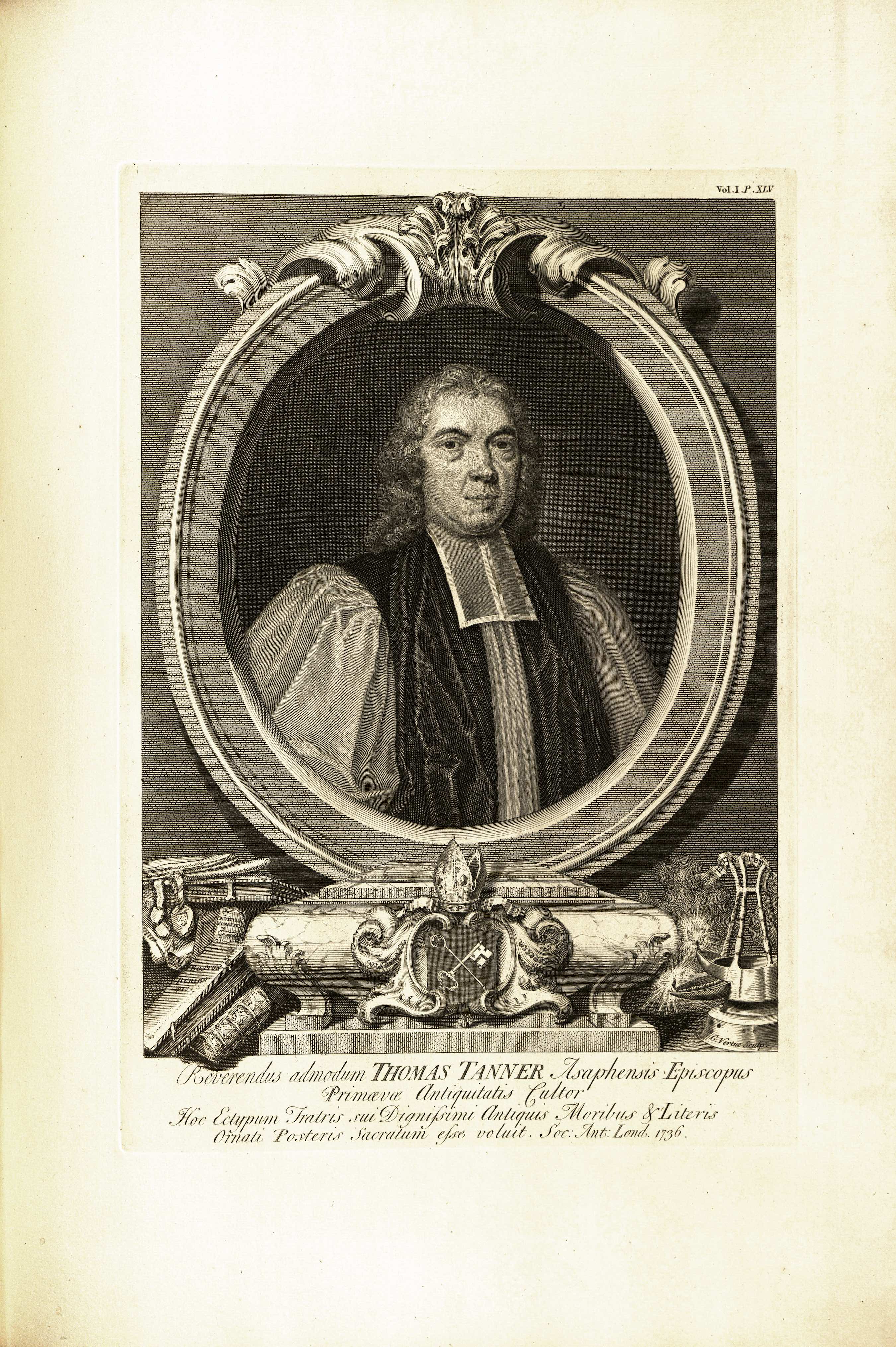
Fenn includes eight portraits in his list, but not all of these are ancient. In the commentaries in this edition there is a special focus on the portraits of modern antiquaries (Plates 1.45, 1.66, 2.3, and 2.28), which Fenn groups somewhat incongruously with historic portraits of Richard II (Plate 1.4) and the twelfth-century monk Eadwin of Canterbury (Plate 2.16). The portraits of antiquaries are of particular interest here because collectively they tell a story about the history of antiquarianism, linking the eighteenth-century SAL genealogically to the Elizabeth Society of Antiquaries by including Robert Cotton (1571-1631) along with the eighteenth-century antiquaries Thomas Tanner, George Holmes, and Charles Lyttelton (all of whom are honored by engraved portraits in the series shortly after their deaths). Intriguingly, Fenn also includes the two portrait medals of Queen Elizabeth (Plate 1.20) in this category, along with a whole series of portraits by Vertue that were reissued separately from Vetusta Monumenta. Lyttelton’s portrait in 1770 was the last to appear in the series itself.
VI. Historic Prints and Processions:
Only one entry from Vetusta Monumenta appears under this heading in Fenn’s list, the plate set devoted to Henry VIII’s Westminster Tournament Roll of 1510 (Plates 1.21-1.26). As Crystal B. Lake shows in her commentary on that plate set, Vertue is equally concerned to document the medial form of these images, the spectacularly long vellum roll painted with colorful chivalric figures, a virtual procession to rival the tournament itself. Although it does not apply broadly to Vetusta Monumenta, Fenn’s classification remains useful because it places this series in the context of another important publication series of the SAL, the Historical Prints series that ran from 1774-1781, in which Basire’s engraving of the “Field of the Cloth of Gold” is perhaps the most famous entry.
VII. Plans, Maps, and Miscellaneous Prints:
It might be said that Fenn ran out of steam at this point in his classification project, or perhaps the final “Miscellaneous” grouping (VII.2) had to be created for those five plates that just wouldn’t fit anywhere else. Volume I, in fact, includes two maps of Roman Britain: both Stukeley’s map of Verulamium (Plate 1.8) and Francis Drake’s Plan of the Roman Roads in Yorkshire (Plate 1.47), which is (oddly) overlooked by Fenn. The two plans listed by Fenn—a plan of the Tower Liberties from 1597 (Plate 1.63) and a plan of London after the Great Fire (Plates 2.1-2.2)—are both quite modern and are quite similar in style and approach.
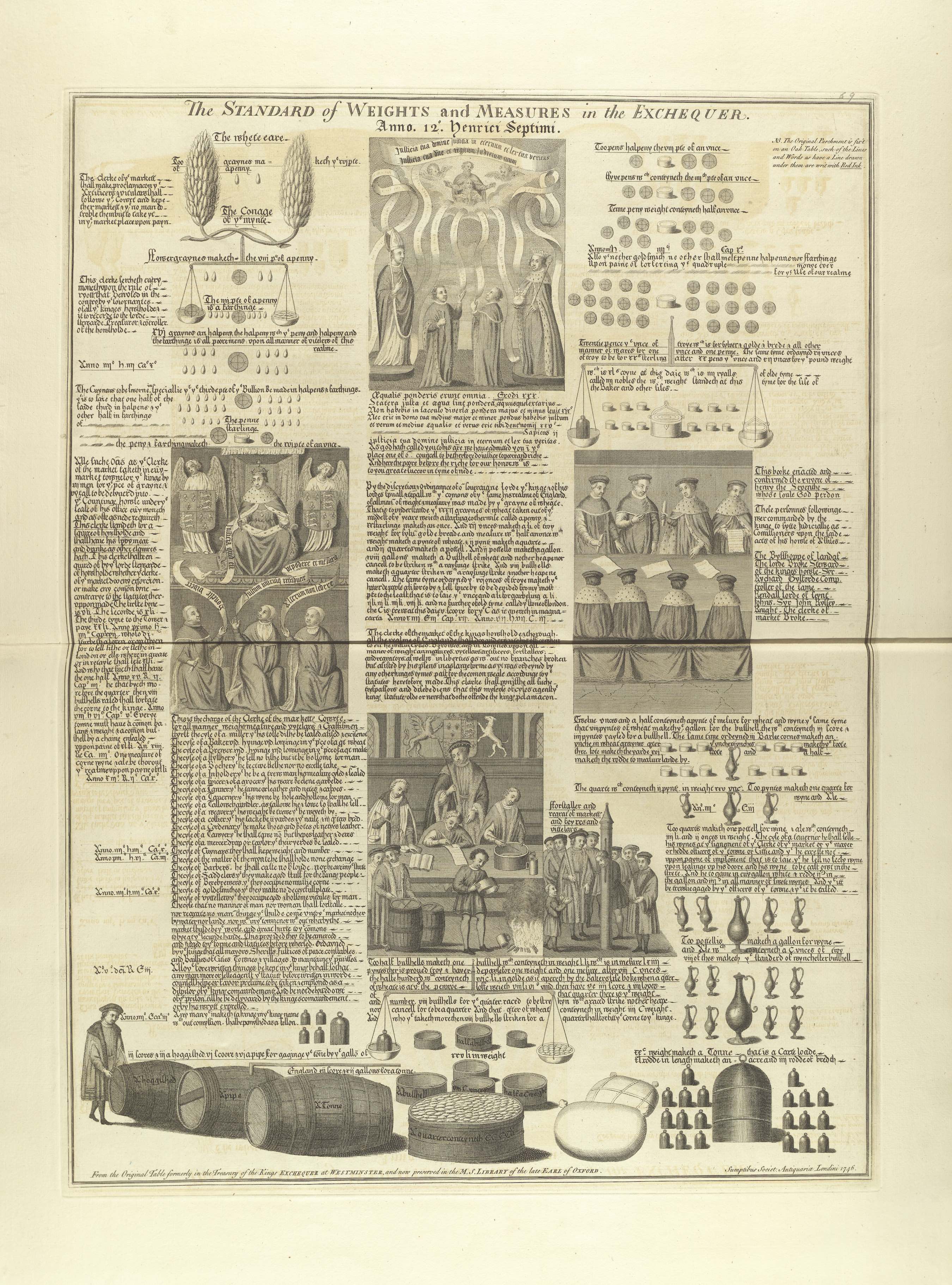
Fenn’s “miscellaneous” antiquities—an arbitrary and incomplete subset, but nonetheless indicative—comprise fragments of the Cotton Genesis MS after it was decimated by the Cotton Library fire of 1731 (1.67-1.68); the exechequer’s Standard of Weights and Measures, an exquisitely illuminated black-letter manuscript from the reign of Henry VII (Plate 1.69); two medieval bronze bells, which even to Fenn do not seem to fit with the Roman bronze objects with which Vertue grouped them (Plate 2.17); a medieval mantlepiece from Saffron Waldon (2.19); and curiously, the 1747 title page and catalogue from Volume I of Vetusta Monumenta itself.
Works Cited:
Fenn, John. 1784. “An Index to the Prints Published by the Society of Antiquaries.” In Three Chronological Tables, Exhibiting a State of the Society of Antiquaries, 17-30. London: J. Nichols.
Gough, Richard. 1786-1796. Sepulchral Monuments in Great Britain. London: J. Nichols.
Myrone, Martin. “The Society of Antiquaries and the Graphic Arts.” In Visions of Antiquity: The Society of Antiquaries of London, 1707-2007, edited by Susan Pearce, 98-121. London: The Society of Antiquaries.
Stukeley, William. 1717. “Articles of Incorporation.” Society of Antiquaries of London, Manuscripts MS 265. [SAL Minutes, Vol. 1].1